 AlbertaSell
County property owners
Selling property in Sturgeon County.
A subdivision name identifies a starting point. For a useful review, bring the exact parcel, its services and the features a buyer can use on possession.
Find your area ↓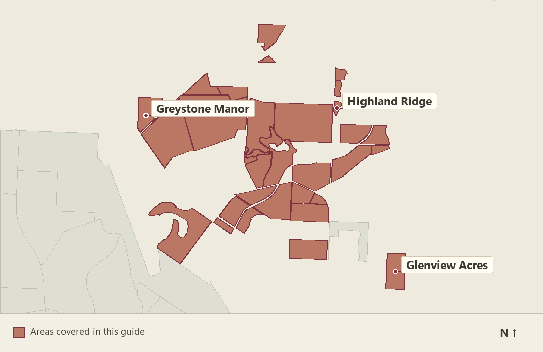
Locate your property.
Search by the subdivision’s full name, including its phase where applicable. The county property viewer accepts an address, legal description or roll number; use it to confirm the parcel first.
Find your subdivision
Keep similarly named areas separate
Sturgeon Heights
Sturgeon County and the City of St. Albert both map an area named Sturgeon Heights. Start with the county and the lot’s legal description. A St. Albert city house is a different comparison if tenure, land, services or municipal jurisdiction differ.
County road mapping shows View Dr. Road source ↗
Allin Ridge Estates
Allin Ridge Estates and Allin Ridge Pointe are separate mapped areas. Begin with the correct address and registered plan; compare a sale in the other area only after identifying its land size, building form and actual services.
County road mapping shows Edinburgh Rd and Dunbar Cl. Road source ↗
Allin Ridge Pointe
Use Allin Ridge Pointe as the subdivision name in your pricing request. County road labels include Allin Ridge Road. Record the buyer’s vehicle route into your lot and check whether a comparison in Allin Ridge Estates offers the same access and useful parking.
County road mapping shows Allin Ridge Rd. Road source ↗
Crestview Heights
Crestview Close is mapped in Crestview Heights, while Crestview Drive also appears as a street in Sturgeon Crest. Mark the actual title on the county viewer before using sales returned by a street-name search.
County road mapping shows Crestview Cl. Road source ↗
Lower Manor Estates
Lower Manor Estates is distinct from Upper Manor Estates and Manor Estates II. For an Equestrian Place address, identify actual existing facilities and permitted use before describing the property. The road name alone cannot establish suitability for livestock.
County road mapping shows Equestrian Pl. Road source ↗
Lower Viscount Estates
The county maps both Lower and Upper Viscount Estates. Match the lot and access first, particularly when using a reference from Viscount Road. Compare site grade, approach and improvements rather than treating the upper and lower names as interchangeable.
County road mapping shows Viscount Rd and Sturgeon Rd. Road source ↗
Manor Estates II
Preserve the phase number when locating Manor Estates II sales. Sturgeon View Crescent and Royal Glen Place are local road references. For a cross-phase comparison, write down land area and documented services before discussing the house finishes.
County road mapping shows Sturgeon View Cr and Royal Glen Pl. Road source ↗
Sturgeon Crest
Sturgeon Crest includes Crestview street names, yet the county separately lists Crestview Heights. Use the parcel on the county map to avoid duplicate comparisons. Sort the valid examples by property type, lot size and usable improvements.
County road mapping shows Crestview Dr and Crestview Pl. Road source ↗
The Banks of Sturgeon Valley
The Banks of Sturgeon Valley has Estate Way street names that also appear elsewhere in the valley. Pin the registered parcel and distinguish its particular setting from other estate phases before using an advertised comparison.
County road mapping shows Estate Way Cr and Estate Way Dr. Road source ↗
Upper Manor Estates
Estate Way and Villa Drive appear in Upper Manor Estates. Upper Manor Pointe is a separate named county subdivision. Keep your title, building records and sales examples tied to the correct phase when presenting an owner’s pricing review.
County road mapping shows Estate Way and Villa Dr. Road source ↗
Upper Manor Pointe
Upper Manor Pointe and Upper Manor Pointe III have distinct boundaries. Confirm the plan associated with Manor Pointe Court on your title. Cross-phase evidence should identify any difference in improvements, service arrangements and setting.
County road mapping shows Manor Pointe Ct. Road source ↗
Upper Manor Pointe III
Retain “III” in the name when searching records around Estate Way Drive and Manor Pointe Place. Make a list of work completed since purchase and compare finished properties from the correct phase before considering unbuilt or differently serviced land.
County road mapping shows Estate Way Dr and Manor Pointe Pl. Road source ↗
Upper Viscount Estates
Viscount Drive, Viscount Crescent and Viscount Place appear in Upper Viscount Estates. To use a Lower Viscount example, document why the approach, land and residence are genuinely comparable. Carry the upper-phase name into the valuation request.
County road mapping shows Viscount Dr and Viscount Cr. Road source ↗
Lot position and access
Bristol Oaks
Bristol Oaks includes several named roads, among them Brittany Crescent and Bristol Way. Show the approach used for everyday entry and the route to any detached garage. Ask whether another sale’s usable driveway, frontage and improvement layout are comparable.
County road mapping shows Brittany Cr and Bristol Way. Road source ↗
Fairway Boulevard
The county maps Fairway Boulevard as a subdivision as well as a road name. Use the registered lot to establish its boundaries and outlook. A fairway view or private access should be described only when it is supported for that property.
County road mapping shows Fairway Blvd. Road source ↗
Green Acres
Ravine Drive is a road reference in Green Acres. Before marketing a lot by reference to the ravine, show the view, yard grade and title boundaries on the actual site. A street name alone does not establish frontage or use rights.
County road mapping shows Ravine Dr. Road source ↗
Highland Ridge
Use the county property viewer to locate Highland Ridge by the legal description or roll number. If a nearby sale has a similar acreage figure but different terrain, compare driveway grade, building envelope and the part of the land usable for the buyer’s intended purpose.
North Point
The mapped North Point area includes numbered avenues and Main Street. When reviewing another sale, check access and frontage near those local roads instead of assuming a rural postal address automatically implies a large country-residential parcel.
County road mapping shows 1 Ave and 2 Ave. Road source ↗
River's Gate
County mapping locates streets including Riverview Way within River’s Gate. Photograph the view from the house and confirm the property’s actual boundary before describing river access. Keep the lot’s current condition separate from a builder’s earlier presentation.
County road mapping shows Riverview Way and Riverview Court. Road source ↗
Only part of this area falls within the service perimeter. Include your address to check coverage.
Riverstone Pointe
For Riverstone Pointe, identify the parcel’s relationship to Riverstone Drive or Riverridge Road and the grade from house to yard. If the comparison involves a walkout, confirm whether the space is finished and how much area is above grade.
County road mapping shows Riverstone Dr and Riverridge Rd. Road source ↗
Summerbrook Estates
The county road map places Valleyview Crescent and River Lane in Summerbrook Estates. Describe the actual arrival, outlook and rear boundary on your property. A similar address near the river does not alone establish equivalent views or access.
County road mapping shows Valleyview Cr and River Lane. Road source ↗
The Crossing at River's Edge
The subdivision name and Rivers Edge Place are location clues. For pricing, document what the buyer owns and which routes are public, private or shared. Ask the agent to keep access rights, actual views and building condition as separate parts of the comparison.
County road mapping shows Rivers Edge Pl. Road source ↗
Tuscany Hills
Via Tuscano and Via Colina are street references in Tuscany Hills. Show the orientation, approach and working yard area of your own property. Where another house has a similar floor plan, room outlook, grade and finished landscaping may still differ.
County road mapping shows Via Tuscano and Via Colina. Road source ↗
Services and outbuildings
Skyglen Air Park
A Sturgeon County planning report describes 18 residential lots in this subdivision, with private water and wastewater servicing. For a sale review, bring the legal lot size, a site plan showing the house and any detached buildings, and records for the water and sewage systems serving your property. Start with comparable residential acreage sales that have similar servicing and usable land. If access to an airstrip is part of your proposed listing, ask your real estate lawyer to verify the specific registered agreement and what transfers with the sale.
Glenview Acres
A buyer comparing two Glenview Acres properties may be comparing quite different improved sites. Separate house area from shop, equipment storage and ancillary spaces. Bring records for the services connected to those structures.
County road mapping shows Glenview S and Glenview Pl. Road source ↗
Greystone Manor
For a property around Greystone Drive or Gladstone Court, bring site and building records for improvements added after purchase. Ask whether the comparison already included that landscaping, garage finish and utility work when it changed hands.
County road mapping shows Greystone Dr and Gladstone Crt. Road source ↗
Noroncal
A Noroncal property on a named local street can require a different set of comparable parcels from a large unserviced acreage. List the existing service connections, lot dimensions and buildings in use before selecting the relevant type of sale.
County road mapping shows Crozier Dr and Crozier Ave. Road source ↗
Pinnacle Ridge
County mapping distinguishes Pinnacle Way, Pinnacle Lane and Pinnacle Place. Assemble the parcel records for the correct address. Where a comparison has an extra garage bay or larger outbuilding, verify dimensions and servicing rather than comparing by the number of structures.
County road mapping shows Pinnacle Way and Pinnacle Lane. Road source ↗
Regency Estates
For a Regency Estates sale near Essex Point, bring dates for mechanical replacements, site work and any utility upgrades. An improvement may change maintenance exposure without increasing value by its full invoice cost; ask the agent to show how it affects the comparison.
County road mapping shows Essex Pt. Road source ↗
Richfield Estates
Start a Richfield Estates valuation with the full site inventory. If your purchase file described a barn or workshop, check its current condition, use and services before carrying the older description into a new sale.
County road mapping shows Richfield Dr. Road source ↗
Trestle Ridge Estates
For a Trestle Ridge Place property, compare the existing home, finished site and any detached structure separately. If the closest reference is an undeveloped lot, note the additional time, construction and service connections a buyer would still need.
County road mapping shows Trestle Ridge Pl. Road source ↗
Before a review
What supports the asking range?
A clear ownership description
Confirm the lot and plan number, improvements included in the sale and any shared access or services. Supply the relevant agreements if you have them.
Same-tenure comparisons
Check whether a reference involves vacant land, an improved acreage or another ownership type. Identify the actual house, lot and included improvements before comparing prices.
A usable site record
Measure the approach, parking and outbuilding access where relevant. Describe the current water, waste and utility arrangements without assuming neighbours have the same setup.
Sturgeon County
Discuss your Sturgeon County sale.
On the Alberta-wide form, include your subdivision, civic or legal address and the property feature that is hardest to compare.